Cheedale Approach
Approaches
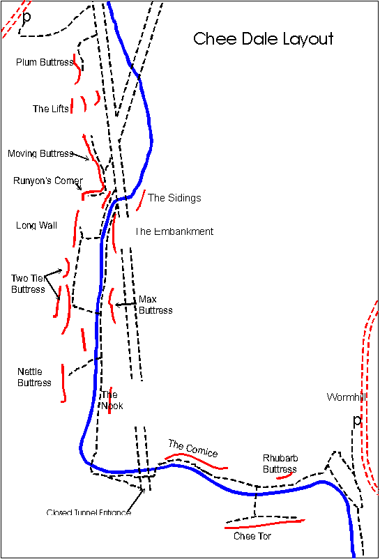
Topley Pike car park and layby
If approaching from the west, take the A6 out of Buxton for 3 miles and locate a pay and display car park at the foot of a long inclined hill: the lower Topley Pike car park.
Alternatively at the top of this hill lies the free Topley Pike layby on the left. Both of these parking places allow access to the old railway track, The Monsal Trail, which runs the full length of the valley. This tracks runs directly out of the lower Topley car park. From the upper east end of the layby go through a gate in the wall and follow the path round and down the hill to join the Monsal Trail at the bottom. Turn right on this to head towards the the Cheedale crags.
Miller’s Dale
When travelling west on the B6049 go down a long hill and pass through the hamlet of Millers Dale. After 500m there is a sharp right on a small road signposted for Wormhill. Just beyond this there are a few parking places on the left of the road. Otherwise take the road for Wormhill and after 100m turn left into a pay and display car park in the old station. This can be reached from the A6 side, this time turning left for Wormhill.
From the far (west) end of the car park take the Monsal Trail and follow it for 800m to a long tunnel. When the tunnel ends go through a gap in the wall on the left and follow the path and stone steps down to the a path along the river. Turn right for The Cornice, Rhubarb Buttress and Chee Tor or left for most of the other crags.
Wormhill
An alternative option, less popular now, is to continue past the Miller Dale station and follow the Wormhill road for 1 mile until a small cottage is seen on the left, the first building on the left, in the tiny hamlet of Wormhill. A few parking spots can found nearby. Descend a small track past the cottage and take the right-hand branch into the dale at a small footbridge. The first buttress, Rhubarb Buttress, lies 200 yards beyond this.
Access
Cheedale is a nature reserve subject to the strongest forms of envrionmental protection. There is no access by negotiated concession to all the right bank and much of the left bank. For detailed current access arrangements, please check the BMC’s Regional Access database.